|
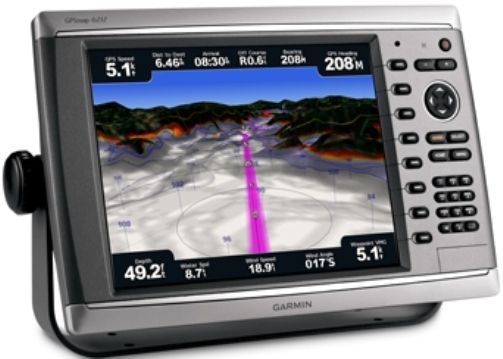
Garmin 010-00751-01 Model GPSMAP 6212 Chartplotter, 12.1" diagonal color LCD size, Display resolution 1024 x 768 pixels, Preloaded BlueChart g2 maps of the coast United States, including Alaska, Hawaii and the Bahamas, External Antenna, 4 NMEA 0183 inputs, 2 NMEA 0183 outputs, 2 video inputs for onboard cameras, 1 PC monitor video output, SD card slot (0100075101 01000751-01 010-0075101 GPSMAP6212 GPSMAP-6212)
SKU: 0100075101
Brand: Garmin
|
|
|
|
|
|
Retrieving current price...
Add to
Cart Qty:
|
|
|
Estimate
Shipping Cost: Choose the quantity to add to cart, press the "Add to Cart" button and in the
Shopping Cart press
"Calculate Shipping".
Availability:
In Stock (see Disclaimer below).
|
|
|
|
|
|
|
Garmin 010-00751-01 Model GPSMAP 6212
Chartplotter, 12.1" diagonal color LCD size, Display resolution 1024 x 768
pixels, Preloaded BlueChart g2 maps of the coast United States, including
Alaska, Hawaii and the Bahamas, External Antenna, 4 NMEA 0183 inputs, 2 NMEA
0183 outputs, 2 video inputs for onboard cameras, 1 PC monitor video output, SD
card slot, Garmin radar compatible, Garmin sonar compatible, Garmin Marine
Network compatible, Supports AIS (tracks target ships' position), Supports DSC
(displays position data from DSC capable VHF radio), Audible alarms, Tide
tables, Sun and moon information
|
General Information |
|
Manufacturer |
Garmin |
|
Manufacturer Part Number |
010-00751-01 |
|
Product Name |
Model GPSMAP� 6212 Chartplotter |
|
Marketing Information |
Unleash a new level of power across your
helm with the GPSMAP 6212. This premier chartplotter is the next
evolution in Garmin�s series of full-featured marine products. The
GPSMAP 6212 comes standard with preloaded BlueChart� g2 maps of the U.S.
coast as well as video-quality resolution on an impressive 12.1� XGA
display. The GPSMAP 6212 also provides total system integration �
allowing support for the addition of sonar, radar, weather and more. For
additional enhanced features, you can add the optional BlueChart� g2
Vision� card.Designed to Move
The
GPSMAP 6212 brings unprecedented speed to your vessel with Garmin G
MotionTM technology � the future of marine technology today.
With blazing-fast map redraw and refresh rates, you�ll have near
real-time data to guide you. Whether you�re in a crowded harbor or in
uncertain weather, you�ll have the confidence you need to navigate your
surroundings with the GPSMAP 6212 as your guide. The GPSMAP 6212 is also
compatible with an optional remote for added flexibility. And with a
sleek and stylish design that was built to brave the elements, the
GPSMAP 6212 looks great in any helm.
View Detailed Graphics and Video
The GPSMAP 6212 features highly
detailed BlueChart g2 marine cartography of the coastal United States,
including Alaska, Hawaii and the Bahamas. And for more detail, you can
easily add maps with the SD� card slot without having to connect to a
computer. The GPSMAP 6212�s high-speed processor draws maps quickly, and
its simple intuitive interface makes navigating easy. To keep tabs on
your engine room or other area of your boat, you can also connect a live
video feed with the GPSMAP 6212�s video input and output options. The
GPSMAP 6212 also comes standard with a wide range of brightness options
- from sunlight-readable to low-light conditions, you can adjust the
setting to match the your surroundings.
Add Extras with BlueChart g2 Vision
With the optional BlueChart g2 Vision
SD card, you can add a whole new dimension of exceptional features to
your chartplotter.
- MarinerEye view and FishEye view
provide you a 3-dimensional perspective of map information, both
above and below the waterline.
- High-resolution satellite images
and aerial photographs help you orient yourself in unfamiliar areas.
- Auto Guidance technology searches
through all relevant charts to create a route you can actually
follow � one that avoids obstacles, shallow water, buoys and other
obstructions.
Connect to the your network
The GPSMAP 6212 easily connects to your
network - providing system integration so you can interface with
additional MFDs and add remote sensors. Once connected, you can share
information between the GPSMAP 6212 and other chartplotters on your
boat. You can also add high-powered radar, sonar and XM satellite
weather and radio to your system. |
|
Features |
- Garmin radar compatible
- Garmin sonar compatible
- Garmin Marine Network� compatible
- Supports AIS (tracks target ships'
position)
- Supports DSC (displays position
data from DSC capable VHF radio)
- Audible alarms
- Tide tables
- Sun and moon information
- 3-D map view (with optional
BlueChart g2 Vision card)
- Auto Guidance (with optional
BlueChart g2 Vision card)
- XM WX Weather & Radio for U.S. &
Canada compatible
- Audio/video input/output
- Interface Inputs/Outputs: 4 NMEA
0183 inputs, 2 NMEA 0183 outputs; 2 video inputs for onboard
cameras, 1 PC monitor video output
|
|
Specifications |
|
Physical & Performance |
|
Unit dimensions, WxHxD |
15.0" x 9.9" x 5.9" (38.2 x 25.1 x 14.9
cm) |
|
Display size, WxH |
9.7" x 7.3", 12.1" diagonal (24.6 x 18.4
cm, 30.7 cm diagonal) |
|
Display resolution, WxH |
1024 x 768 pixels |
|
Display type |
XGA display |
|
Weight |
15.9 lb (7.2 kg) |
|
Waterproof |
yes (IPX7) |
|
High-sensitivity receiver |
yes |
|
Antenna |
external |
|
NMEA input/output |
NMEA 0183, NMEA 2000 |
|
Maps & Memory |
|
Basemap |
yes |
|
Preloaded maps |
yes (coastal maps) |
|
Ability to add maps |
yes |
|
Built-in memory |
none (cannot load maps to internal memory) |
|
Accepts data cards |
SD� card slot (BlueChart g2 Vision cards
sold separately) |
|
Waypoints/favorites/locations |
5,000 |
|
Routes |
100 |
|
Track log |
50,000 points; 50 saved tracks |
A-20110428-1404-130-L
*This item is BRAND NEW -
not refurbished. It comes with all manufacturer supplied accessories, and full
manufacturer's USA warranty.
|