|
Garmin 010-00692-11 Model GPSMAP 5215 Chartplotter, Touchscreen XGA Display, 15-Inch screen make navigation, Resolution 1024 x 768 pixels, 1,500 Waypoints, 20 Routes, Highly-detailed BlueChart g2 marine cartography of the coastal United States, including Alaska, Hawaii and the Bahamas, UPC 753759080341, Alternative to 010-00692-01 0100069201 (0100069211 GPSMAP5215 GPSMAP-5215)
SKU: 0100069211
Brand: Garmin
|
|
|
|
|
|
Retrieving current price...
Add to
Cart Qty:
|
|
|
Estimate
Shipping Cost: Choose the quantity to add to cart, press the "Add to Cart" button and in the
Shopping Cart press
"Calculate Shipping".
Availability:
In Stock (see Disclaimer below).
|
|
|
|
|
|
|
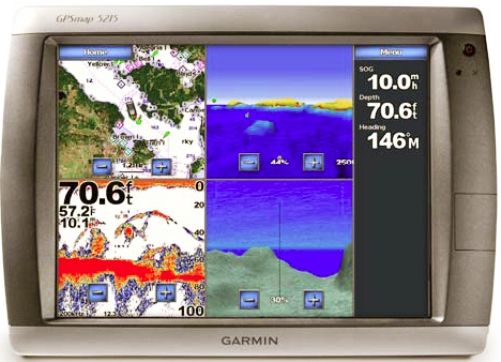
Garmin 010-00692-11 Model GPSMAP 5215
Chartplotter, Touchscreen XGA Display, 15-Inch screen make navigation,
Resolution 1024 x 768 pixels, 1,500 Waypoints, 20 Routes, Highly-detailed
BlueChart g2 marine cartography of the coastal United States, including Alaska,
Hawaii and the Bahamas, UPC 753759080341, Alternative to 010-00692-01 0100069201, External
Antenna, Garmin radar compatible, Garmin sonar compatible, Garmin Marine Network
compatible, Audible alarms, Tide tables, Sun and moon information, XM WX Weather
& Radio for U.S. compatible
|
General Information |
|
Manufacturer |
Garmin |
|
Manufacturer Part Number |
010-00692-11 |
|
Product Name |
Model GPSMAP 5215 Chartplotter |
|
UPC Code |
753759080341 |
|
Marketing Information |
The largest network
plotter display in the Garmin marine line, the GPSMAP
5215 offers true �big picture� navigation.
This chartplotter features
the same menu-driven touchscreen found on its 5,000
series counterparts. Preloaded BlueChart g2 maps of the
U.S. coast and a whopping 15" screen make navigation as
easy as pointing your finger. By connecting to the
Garmin Marine Network, you can add sonar, radar and
weather. And for even more advanced features, you can
add the optional BlueChart� g2 Vision� card. For a low
cost option try BlueChart g2 cards.
View Detailed Graphics
and Video
The GPSMAP 5215
features highly-detailed BlueChart g2 marine cartography
of the coastal United States, including Alaska, Hawaii
and the Bahamas. For other areas, the 5215 has a
worldwide basemap with high-quality satellite images in
place of more traditional maps. With the SD� card slot,
you can add additional maps without having to connect to
a computer.
The 5215�s huge XGA
screen displays graphics with crisp, video-quality
resolution. To keep tabs on your engine room or another
area of your boat, you can also connect a live video
feed with the 5215's video input/output options.
Add Extras with
BlueChart g2 Vision
With optional BlueChart
g2 Vision SD cards, you can add a whole new dimension of
exceptional features to your chartplotter.
- Choose to view 3D
map information at "mariner's eye view" above the
waterline or "fish eye view" below the water.
- High-resolution
satellite images and aerial photographs help you
orient yourself in unfamiliar areas.
- Auto Guidance
technology searches through all relevant charts to
create a route you can actually follow � one that
avoids obstacles, shallow water, buoys and other
obstructions.
Connect to the Garmin
Marine Network
The 5215 connects
easily to the high-speed Garmin Marine Network, so you
can interface with additional MFDs and add remote
sensors. Once connected, you can share information
between the 5215 and other chartplotters on your boat.
You can also add high-powered radar, sonar, and XM
satellite weather and radio to your system.
|
|
Features |
- Garmin radar compatible
- Garmin sonar compatible
- Garmin Marine Network� compatible
- Touchscreen
- Supports AIS (tracks target ships'
position)
- Supports DSC (displays position
data from DSC capable VHF radio)
- Audible alarms
- Tide tables
- Sun and moon information
- 3-D map view (with optional
BlueChart g2 maps)
- Auto Guidance (with optional
BlueChart g2 Vision card)
- XM WX Weather & Radio for U.S.
compatible
- Remote control (optional)
- Audio/video input/output
- Interface Inputs/Outputs: 3
built-in network ports, 4 NMEA 0183 inputs, 2 NMEA 0183 outputs, and
NMEA 2000; 2 video inputs for onboard cameras, 1 XGA PC monitor
video output
|
|
Specifications |
|
Physical &
Performance |
|
Unit dimensions, WxHxD |
15.5" x 11.7" x 5.7" (39.4 x 29.7 x 14.5
cm)
|
|
Display size, WxH |
9" x 12", 15" diagonal (22.9 x 30.5 cm,
30.7 cm diagonal)
|
|
Display resolution, WxH |
1024 x 768 pixels
|
|
Display type |
Touchscreen XGA display
|
|
Weight |
11.9 lb (5.4 kg)
|
|
Waterproof |
yes (IPX7)
|
|
High-sensitivity receiver |
no
|
|
Antenna |
external
|
|
NMEA input/output |
NMEA 0183, NMEA 2000
|
|
Maps & Memory |
|
Basemap |
yes
|
|
Preloaded maps |
yes (coastal maps)
|
|
Ability to add maps |
yes
|
|
Built-in memory |
none (cannot load maps to internal memory)
|
|
Accepts data cards |
SD� card slot (BlueChart g2 Vision cards
sold separately)
|
|
Waypoints/favorites/locations |
1,500
|
|
Routes |
20
|
|
Track log |
10,000 points; 20 saved tracks
|
A-20090818-1500-130-E
*This item is BRAND NEW -
not refurbished. It comes with all manufacturer supplied accessories, and full
manufacturer's USA warranty.
|