|
|
|
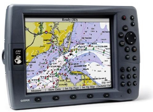
Garmin 010-00525-00 GPSMAP 2210 System With GPS 17
Sensor And built-in BlueChart g2 For US Coastal Waters Incl. Alaska, Hawaii;
10-inch diagonal displays; Bluechart(r) g2(tm) technology features 3d
perspective, tide & current data, shaded depth contours, port plans, wrecks,
restricted areas, etc.; Dual card slots for supplemental bluechart(r) g2(tm)
preprogrammed data cards; Waas-enabled, 12 parallel-channel gps sensor with
30-ft cable length; Ultra-dim backlight for nighttime operation with
user-programmable levels for day & night; Permanent user-data storage
|
General Information |
|
Manufacturer |
Garmin |
|
Manufacturer Part Number |
010-00525-00 |
|
Product Name |
GPSMAP 2210 System With GPS 17 Sensor And built-in
BlueChart g2 For US Coastal Waters Incl. Alaska, Hawaii |
|
Marketing Information |
For boaters looking for value-priced,
large-display color chartplotters with limited networking capability and
preloaded marine cartography, the GPSMAP 2200 series chartplotters are
right on course.
The GPSMAP 2206's 6.4-inch and GPSMAP 2210's 10-inch diagonal displays
let you see more “big picture” navigation detail with less panning and
zooming. Better still, these non-network plotters also come preloaded
with detailed marine cartography utilizing BlueChart® g2 technology.
Built-in coverage is provided for U.S. coastal areas, including Alaska
and Hawaii. These integrated charts provide a smoother, more fluid
presentation on your plotter screen – and they can be viewed in 2D or 3D
“crow’s nest” perspective for easy orientation. Both units accept up to
two optional data cards for loading additional map coverage of inland
lakes or BlueChart® detail for other regions. |
|
Features |
-
Chart plotter
with detail frequency, full-featured ultrascroll(tm) high rep rate
sonar & built-in marine detail charts of us coastline – including
alaska & hawaii
-
Bluechart(r)
g2(tm) technology features 3d perspective, tide & current data,
shaded depth contours, port plans, wrecks, restricted areas, etc.
-
Dual card slots
for supplemental bluechart(r) g2(tm) preprogrammed data cards
-
Waas-enabled, 12
parallel-channel gps sensor with 30-ft cable length
-
640 x 480 pixels
-
Ultra-dim
backlight for nighttime operation with user-programmable levels for
day & night
-
Permanent
user-data storage
-
No-memory battery
required
-
Requires garmin
infrared remote for remote operation
-
Split map & sonar
display
-
Graphical bearing
& course guidance
-
Pre-loaded with
over 15 user-interface languages
-
Stores 4,000
waypoints & 50 reversible routes with up to 300 points each
-
10,000-point
active track log saves up to 15 tracks with up to 750 points each
-
10 proximity
waypoints
-
68 waypoint
symbols
-
Alarms for anchor
drag, arrival, off-course, proximity waypoint, clock, low battery
voltage & gps accuracy
-
Graphically
displays positioning data with dsc-equipped vhf radios
-
Power-down
settings backup: settings are not lost when unit is turned off
-
Requires blank
data card for back-up of user data
-
256-color, 10.4"
tft vga sunlight-readable display
-
Dim: 8.8"h x
13.1"w x 3.25"d
-
Weight: 5.0 lbs.
|
A-20060517-1027-130-E
*This item is BRAND NEW -
not refurbished. It comes with all manufacturer supplied accessories, and full
manufacturer's USA warranty.
|

